
Chris Konrad
(cpkonrad@usgs.gov)
(253) 552-1634
Mark Mastin
(mcmastin@usgs.gov)
(253) 552-1609
Frank Voss
(fdvoss@usgs.gov)
(253) 552-1689
934 Broadway,
Suite 300
Tacoma, WA 98402
Methow River Basin
Scientific Topics -Ground Water
#!/usr/bin/perl -- -*-perl-*- # This script displays the navigation bar for all project pages. #---------------------------------------------------------------------------------------------------------------------- # Print html header #---------------------------------------------------------------------------------------------------------------------- print "Content-type: text/html\n\n"; #---------------------------------------------------------------------------------------------------------------------- # Retrieve query string and specify variables for links. #---------------------------------------------------------------------------------------------------------------------- $publications_link = "Publications and Products | "; $links_link = "Related Links | "; $news_link = "News Releases | "; $data_link = "Data | "; $maps_link = "Maps | "; $science_link = "Scientific Topics | "; $bibliography_link = "Bibliography | "; $status_link = "Status | "; $database_link = "Database | "; $acknowledge_link = "Acknowledgments | "; $photo_link = "Photo Gallery | "; $asses_link = "Assessment Document | "; $gis_link = "GIS and Aerial Photography Sources | "; $contact_link = "Contact Us | "; $flood_link = "Flood Hazards | "; $path = $ENV{'QUERY_STRING'}; $path =~ s/%([0-9|A-F]{2})/pack("C",hex($1))/eg; $path =~ s/[;<>\*\|'&\$!#\(\)\[\]\{\}:"\\\/]//g; $path = "../projects/".$path."/includes/".$path.".config"; #---------------------------------------------------------------------------------------------------------------------- # Open the configuration file for the specific project. #---------------------------------------------------------------------------------------------------------------------- require $path; #---------------------------------------------------------------------------------------------------------------------- # Print table head #---------------------------------------------------------------------------------------------------------------------- print qq~| Project Home | ~; #---------------------------------------------------------------------------------------------------------------------- # Determine which links to display for specific project, based on configuration file. #---------------------------------------------------------------------------------------------------------------------- while ($status > 0) { print "$status_link"; $status = 0; } while ($publications > 0) { print "$publications_link"; $publications = 0; } while ($links > 0) { print "$links_link"; $links = 0; } while ($news > 0) { print "$news_link"; $news = 0 } while ($data > 0) { print "$data_link"; $data =0; } while ($maps > 0) { print "$maps_link"; $maps = 0; } while ($science > 0) { print "$science_link"; $science = 0; } while ($bibliography > 0) { print "$bibliography_link"; $bibliography = 0; } while ($database > 0) { print "$database_link"; $database = 0; } while ($acknowledge > 0) { print "$acknowledge_link"; $acknowledge = 0; } while ($photo > 0) { print "$photo_link"; $photo = 0; } while ($asses > 0) { print "$asses_link"; $asses = 0; } while ($gis > 0) { print "$gis_link"; $gis = 0; } while ($contact > 0) { print "$contact_link"; $contact = 0; } while ($flood > 0) { print "$flood_link"; $flood = 0; } #---------------------------------------------------------------------------------------------------------------------- # Print table footer #---------------------------------------------------------------------------------------------------------------------- print qq~ Project Summaries | Partnerships | | |
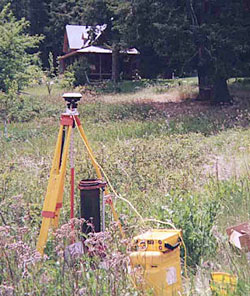 View of domestic well with differential global positioning satellite receiver (on tripod) used for precise determination of well-head elevation and electronic tape (red spool with black handle) used to measure depth to water in the well. (Photograph taken by Robin Smith, U.S. Geological Survey, June 2001.)
 Ground water is an important resource in the Methow River Basin. Ground water sustains streamflow during dry months when there is little rain to generate runoff. Ground water moderates temperatures of streams and rivers because it is relatively cool in the summer and warm in the winter. Ground water also supplies water for domestic, agricultural, and other commercial uses.
Aquifers in the unconsolidated sediments deposited along valley bottoms provide the closest and, in all likelihood, the largest supply of ground water for streams and public use. The U.S. Geological Survey (USGS) inventoried and monitored nearly 400 wells throughout the valley to characterize the unconsolidated deposits and confining layers in the basin. The USGS will use lithologic information from the well drillers' logs to map the thickness of hydrogeologic units.
Periodic water-level measurements from the wells will be used to map the altitude of ground water in the basin. The hydrogeologic framework in combination with the ground-water altitudes will improve the understanding of the unconsolidated aquifers throughout the basin.