National Water-Quality Assessment (NAWQA) --
Central Columbia Plateau, Washington and Idaho
Open-File Report 91-164
G.C. Bortleson, 1991
Background | Study Unit Description | Water-Quality Issues | Communication and Coordination | More Information....
BACKGROUND

In 1991, the U.S. Geological Survey (USGS) began implementing a full-scale National Water-Quality Assessment (NAWQA) program. The long-term goals of the NAWQA program are to describe the status and trends in the quality of a large, representative part of the Nation's surface- and ground-water resources; and to provide a sound, scientific understanding of the primary natural and human factors affecting the quality of these resources. In meeting these goals, the program will produce a wealth of water-quality information that will be useful to policymakers and managers at the national, state, and local levels.
A major design feature of the NAWQA program is the concept of study-unit investigations. These investigations comprise the principal building blocks upon which national-level assessment activities will be based. The 60 study-unit investigations that make up the program represent parts of most major river basins and aquifer systems in the Nation. These study units are 1,200 to more than 65,000 square miles in areal extent and incorporate about 60 to 70 percent of the Nation's water use and population served by public water supply. In 1991, investigations were started in 20 study units located throughout the Nation; the Central Columbia plateau in eastern Washington and western Idaho, described below, is one of these units.
Top
STUDY UNIT DESCRIPTION
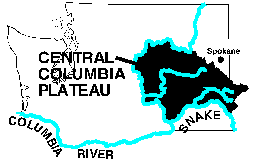
The Central Columbia plateau, comprising 13,100 square miles in eastern Washington and western Idaho, is drained by the Columbia River and its major tributaries--the Snake River, Crab Creek, and Palouse River (fig. 1). The region is dominated by agricultural activities on irrigated and nonirrigated land. The plateau is underlain by massive basalt flows and sedimentary deposits overlie the basalt over large areas. In the west-central part of the plateau, floodwaters during the Pleistocene stripped away overlying sediments and left behind deep canyons and coulees. In the southeastern part of the plateau, loess was deposited over undeformed basalt, forming rolling hills. The basalt aquifers in the plateau, in particular the interflow zones, are a major source of water for agricultural, domestic, and municipal use.
Most of the plateau is semiarid and receives less than 15 inches of precipitation per year. Major land uses, in order of coverage, are nonirrigated agriculture, irrigated agriculture, and livestock grazing. Overall, there has been a temporal increase in irrigated acreage throughout the plateau and a trend toward fewer but larger farms. Irrigation water made available by the Columbia River Irrigation Project and through drilling of deep wells in the basalts spurred growth in the area from the 1950's through the 1970's. The present population of 200,000, however, has grown slowly since the 1960's. Water use (excluding that used only for hydropower) during l985 totaled about 3,000 mgal/d (million gallons per day); about 80 percent was surface water used for irrigation. The primary surface-water source of irrigation water is the Columbia River. Irrigation with ground water accounted for only about 14 percent of the total water used in 1985. Persistent declines of ground-water levels have occurred in parts of the plateau. The declines are almost exclusively in areas of sizable pumping for irrigation. In other areas of the plateau, water levels have risen because of the large amounts of surface water applied for irrigation.
The USGS has completed an extensive study of the regional aquifer system underlying the plateau. The study described the geohydrology, geochemistry, and regional flow system of the major basalt formations and of the interflow zones. Geochemical factors controlling the occurrence of sodium in the ground water of the plateau also was studied.
Top
WATER-QUALITY ISSUES
The key water-quality and related issues in the irrigated western part of the plateau are:
- Elevated concentrations of nutrients and trace organic compounds in surface and
ground waters;
- Eutrophic conditions and obnoxious aquatic plants in some streams and lakes;
- Low flows and low dissolved-oxygen concentrations in surface water;
- Elevated temperatures and large concentrations of bacteria and suspended sediment in surface water;
- Elevated concentrations of sodium in surface and ground waters in areas irrigated with ground water;
- Waterlogging of soils in areas irrigated with surface water.
The water-quality and related issues in the eastern part of the plateau used for dry-land farming and grazing include:
- Erosion of soil caused by rainfall and snowmelt, especially on frozen ground;
- Streambed deposition of fine sediment which covers spawning gravels and causes dissolved-oxygen depletion;
- Low flows and ground-water level declines;
- Elevated temperatures, pH, and concentrations of ammonia and bacteria in surface water;
- Deteriorated habitat for fisheries resulting from poor land- and water-use practices.
Top
COMMUNICATION AND COORDINATION
Communication and coordination between Geological Survey personnel and other interested scientists and water-management organizations are critical components of the NAWQA program. Each of the study-unit investigations will have a local liaison committee consisting of representatives who have water-resources responsibilities from federal, state, and local agencies, universities, and the private sector. Specific activities of each liaison committee will include (1) the exchange of information about water-quality issues of regional and local interest, (2) the identification of sources of data and information, (3) assistance in the design and scope of project products, and (4) the review of project planning documents and reports. Liaison committees for the Central Columbia study unit will be formed in 1991.
Top
Information on technical reports and hydrologic data related to the NAWQA program can be obtained from:
Robert W. Black, Project Chief
1201 Pacific Ave., Suite 600
Tacoma, WA 98402
Phone: (253) 428-3600 ext 2687 Fax: (253) 428-3614
Email: rwblack@usgs.gov
Central Columbia Plateau - Yakima
River Basin NAWQA Study || Water Resources
of Washington State
Water Resources of the United States || U.S. Geological Survey
This page maintained by Sarah J. Ryker [ sjryker@usgs.gov ]
Last modified: Thurs March 28, 2:45 p.m.
