
Search our site:
Mud Mountain Dam and Reservoir
US Army Corps of Engineers - Seattle District
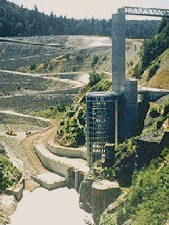
Mud Mountain Dam and Intake
Structure. Photo Courtesy
of US Army Corps of Engineers,
Seattle District Office
The Corps of Engineers Reservoir Control Center, Seattle District Office, operates Mud Mountain Dam on the White River. The Corps operates six sensors on the dam intake structure in addition to making visual inspections to determine the elevation of the reservoir. The sensors range from 896 feet to 1070 feet with other sensors at 910, 932, 980 and 1025 feet. The sensor at 910 feet is the primary sensor along with visual inspections below 910 feet. The other sensors serve as redundancy when there are problems with the primary sensor.
Links to Other Data Pages
- Current Hydrologic Conditions
- Historical Data
- Related Hydrologic Information
- Surface Water Reports
- Water Resources Agencies and Information
List of Federal and Washington State Agencies and information resources