
Chris Konrad
(cpkonrad@usgs.gov)
(253) 552-1634
Mark Mastin
(mcmastin@usgs.gov)
(253) 552-1609
Frank Voss
(fdvoss@usgs.gov)
(253) 552-1689
934 Broadway,
Suite 300
Tacoma, WA 98402
Methow River Basin
Scientific Topics - Ground Water and Surface Water Interaction
#!/usr/bin/perl -- -*-perl-*- # This script displays the navigation bar for all project pages. #---------------------------------------------------------------------------------------------------------------------- # Print html header #---------------------------------------------------------------------------------------------------------------------- print "Content-type: text/html\n\n"; #---------------------------------------------------------------------------------------------------------------------- # Retrieve query string and specify variables for links. #---------------------------------------------------------------------------------------------------------------------- $publications_link = "Publications and Products | "; $links_link = "Related Links | "; $news_link = "News Releases | "; $data_link = "Data | "; $maps_link = "Maps | "; $science_link = "Scientific Topics | "; $bibliography_link = "Bibliography | "; $status_link = "Status | "; $database_link = "Database | "; $acknowledge_link = "Acknowledgments | "; $photo_link = "Photo Gallery | "; $asses_link = "Assessment Document | "; $gis_link = "GIS and Aerial Photography Sources | "; $contact_link = "Contact Us | "; $flood_link = "Flood Hazards | "; $path = $ENV{'QUERY_STRING'}; $path =~ s/%([0-9|A-F]{2})/pack("C",hex($1))/eg; $path =~ s/[;<>\*\|'&\$!#\(\)\[\]\{\}:"\\\/]//g; $path = "../projects/".$path."/includes/".$path.".config"; #---------------------------------------------------------------------------------------------------------------------- # Open the configuration file for the specific project. #---------------------------------------------------------------------------------------------------------------------- require $path; #---------------------------------------------------------------------------------------------------------------------- # Print table head #---------------------------------------------------------------------------------------------------------------------- print qq~| Project Home | ~; #---------------------------------------------------------------------------------------------------------------------- # Determine which links to display for specific project, based on configuration file. #---------------------------------------------------------------------------------------------------------------------- while ($status > 0) { print "$status_link"; $status = 0; } while ($publications > 0) { print "$publications_link"; $publications = 0; } while ($links > 0) { print "$links_link"; $links = 0; } while ($news > 0) { print "$news_link"; $news = 0 } while ($data > 0) { print "$data_link"; $data =0; } while ($maps > 0) { print "$maps_link"; $maps = 0; } while ($science > 0) { print "$science_link"; $science = 0; } while ($bibliography > 0) { print "$bibliography_link"; $bibliography = 0; } while ($database > 0) { print "$database_link"; $database = 0; } while ($acknowledge > 0) { print "$acknowledge_link"; $acknowledge = 0; } while ($photo > 0) { print "$photo_link"; $photo = 0; } while ($asses > 0) { print "$asses_link"; $asses = 0; } while ($gis > 0) { print "$gis_link"; $gis = 0; } while ($contact > 0) { print "$contact_link"; $contact = 0; } while ($flood > 0) { print "$flood_link"; $flood = 0; } #---------------------------------------------------------------------------------------------------------------------- # Print table footer #---------------------------------------------------------------------------------------------------------------------- print qq~ Project Summaries | Partnerships | | |
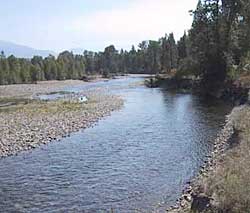 View of ground-water seeps from a side channel (left) providing baseflow to the Methow River. (Photograph taken by C.P. Konrad, U.S. Geological Survey, September 2001.)
Surface-water and ground-water resources are dependent on each other in the Methow River Basin. Surface water, including snowmelt from high-elevation basins, high flows in streams, and irrigation canals recharges ground water, which in turn sustains baseflow in rivers and streams. The U.S. Geological Survey (USGS) has been investigating the interaction of surface water and ground water throughout the Methow River Basin.
At the basin-scale, the interaction between surface water and ground water can be illustrated by the gains and losses in surface flow along a river. During September 2001, large losses of surface flow were measured in the Methow River near Mazama and large gains were measured upstream of Winthrop and, again, upstream of Twisp. Many of the gains and losses are associated with geologic features such as thick deposits of unconsolidated sediments along the valley bottoms shallow bedrock, faults, and narrow valley walls. For rivers where runoff is dominated by snowmelt, like the Methow River, the location, direction, and magnitude of interactions between surface water and ground water vary with the season.
The USGS has been conducting a detailed investigation of ground-water and surface-water interactions in the lower Twisp River valley. As part of the investigation, the USGS will construct a water budget for the valley to estimate the volume and timing of exchanges between ground water and surface water along the river as well as irrigation canals. The USGS monitored river flow, irrigation diversions, ground-water levels, and weather continuously during the irrigation season in 2001 and will continue to monitor river flow and ground-water levels.