
Water Resources of Washington State
USGS Fact Sheet FS-061-97
by M.L. Erwin and A.J. Tesoriero
June 1997
Predicting Ground-Water Vulnerability
to Nitrate in the Puget Sound Basin
What is ground-water vulnerability?
It is an estimate of the relative risk of ground-water
contamination by a particular constituent, such as nitrate.
Where is the ground water most vulnerable?
In the Puget Sound Basin, shallow wells in aquifers
that have coarse-grained glacial deposits at the
surface and a high percentage of urban (residential,
commercial, and industrial) and(or) agricultural
land use in the vicinity are most vulnerable to
nitrate contamination. For example, shallow wells
in agricultural areas overlying coarse-grained
glacial deposits, like much of the Lower Nooksack
Valley, or in urban areas overlying such deposits,
like parts of Tacoma and Olympia, have a greater
than 50% probability of nitrate concentrations at or
above 3 milligrams per liter (areas in red on the
vulnerability map). Nitrate
concentrations at or above 3 milligrams per liter
(mg/L) are well above naturally occurring levels
in the Puget Sound Basin (see Brown and
Caldwell, 1985, for example), indicating an
anthropogenic (human-related) source of nitrate.
Why is vulnerability to nitrate of concern?
- Nitrate contamination has been suggested as an
indicator of overall ground-water quality
(U.S. Environmental Protection Agency, 1996a).
- Because drinking water with high nitrate concentrations
is a potential health risk, the U. S.
Environmental Protection Agency has set a
standard for nitrate in drinking water of 10 mg/L
(U.S. Environmental Protection Agency,
1996b). Identifying areas in the Puget Sound
Basin where ground water has been impacted by
anthropogenic activities (nitrate concentrations
at or above 3 mg/L) can help water resource
managers protect the water supply by targeting
land-use planning and monitoring programs to
these vulnerable areas.
How was ground-water vulnerability to nitrate predicted?
A vulnerability model was created by relating
existing nitrate data to factors describing:
- aquifer susceptibility--the ease with which a
contaminant can reach the aquifer, determined
by natural factors, and
- contaminant availability--the availability of
sources of nitrate at or near the land surface, determined by anthropogenic factors.
Method
Using logistic regression, the
occurrence of elevated nitrate concentrations (at or
above 3 mg/L) in samples from 1,967 public supply
wells was related to natural factors to assess aquifer
susceptibility, and to natural and anthropogenic
factors to assess ground-water vulnerability. Data
were from the Washington State Department of
Health. Significant factors were well depth,
surficial geology, and the percentage of agricultural
and urban land use within a 2-mile radius of a well.
Assessment of aquifer susceptibility
The probability that a well has an elevated nitrate
concentration was related to well depth for each of
three types of surficial geology in the basin (graph a).
![[Graph (a)]](tn-fig2a.gif) Graph (a) (GIF, 23053 bytes)
Graph (a) (GIF, 23053 bytes)
![[Ground-water movement]](tn-fig3.gif) Ground-water movement and susceptibility (GIF, 20583 bytes)
Ground-water movement and susceptibility (GIF, 20583 bytes)
Assessment of ground-water vulnerability
To create the vulnerability model, significant natural
factors were combined with significant
anthropogenic factors: percent agricultural and
percent urban land use within a 2-mile radius of the
well (graph b). (Percent land use was calculated for
a range of radii surrounding each well and related to
the occurrence of elevated nitrate concentrations; a
2-mile radius provided the best fit to the data.)
![[Graph (b)]](tn-fig2b.gif) Graph (b) (GIF, 30157 bytes)
Graph (b) (GIF, 30157 bytes)
Creation of a vulnerability map
The vulnerability map was created using the vulnerability
model (see logistic regression) and geographic
information system (GIS) coverages of the surficial
geology and land uses in the basin. Maps can be
created to depict the probability of elevated nitrate
concentrations for wells of any depth.
Evaluation of the vulnerability model
The model was evaluated using existing data for
1,729 mostly domestic wells in the Puget Sound
Basin. Data were from the USGS National Water
Information System.
How susceptibility and vulnerability
assessments help with water-resource
management
Planning land use
Areas where ground water is more susceptible to
contamination can be identified. This information
can be used in locating land-use activities that are
potential sources of contaminants, such as landfills
and high-density septic systems. Maps that display
the susceptibility of an aquifer system can help
educate the public and encourage its support of suitable
land-use planning.
Targeting ground-water monitoring
Inspections, data collection, and other monitoring efforts
can be targeted to vulnerable areas where land uses that
are known sources of contaminants already exist. For
example, public water systems are required to sample
wells periodically for contaminants. Targeting sampling to
those areas identified as more vulnerable to the
contaminant of interest would result in more effective and
less costly monitoring programs (Ryker and Williamson,
1996; Vowinkel and others, 1996).
Monitoring changes in risk of nitrate contamination of
ground water
The probability of elevated nitrate concentrations
calculated by the vulnerability model can establish a
baseline measure of risk both spatially and with depth.
Models based on subsequent nitrate data, which are
collected periodically, can be used to evaluate changes in
risk over time, which could result from changes in land
use or because nitrate has traveled farther along ground-
water flow paths.
Evaluating risk from other contaminants
Similar models can be created to predict the probability of
detecting pesticides or volatile organic compounds if data
exist; these models can then be used to assess
susceptibility and vulnerability to these contaminants.
However, where data on these contaminants are limited,
models based on nitrate data could be useful for
estimating relative susceptibility (but not vulnerability) to
these other contaminants.
Advantages of this method of predicting ground-water vulnerability
- Vulnerability estimates are based upon statistically
significant relations between water-quality data (in
this case, elevated nitrate concentrations) and
explanatory variables such as surficial geology.
- Unlike methods based on assigning categories of risk
("high" or "low"), this method produces vulnerability
estimates which are probabilities; these numbers can
be directly compared with estimates from other
regions.
- Nitrate data are collected regularly and are widely
available from State health departments and the
USGS National Water Information System, providing
much of the information needed for an inexpensive
assessment of changes in water quality over time.
References
Brown and Caldwell, 1985, Clover/Chambers Creek
geohydrologic study for Tacoma-Pierce County Health
Department [variously paged].
Ryker, S.J., and Williamson, A.K., 1996, Pesticides in public supply wells of Washington
State: U. S. Geological Survey Fact Sheet FS-122-96, 2 p.
U. S. Environmental Protection Agency, 1996a,
Environmental indicators of water quality in the United
States: Washington, D.C., U.S. Environmental Protection
Agency, Office of Water, EPA 841-R-96-002, 25 p.
U.S. Environmental Protection Agency, 1996b, Drinking
water regulations and health advisories: Washington,
D.C., U.S. Environmental Protection Agency, Office of
Water, EPA 822-B-96-002, 11 p.
Vowinkel, E.F., Clawges, R.M., Buxton, D.E., Stedfast, D.A.,
and Louis, J.B., 1996, Vulnerability of public drinking
water supplies in New Jersey to pesticides: U. S.
Geological Survey Fact Sheet FS-165-96, 4 p.
USGS Fact Sheet FS-061-97
By M.L. Erwin and A.J. Tesoriero
June 1997
GIS by F.D.Voss; Illustrations by E.L. Inkpen and C.J. Dean
This fact sheet is based on the journal article
Tesoriero, A.J., and Voss, F.D., 1997, Predicting the
probability of elevated nitrate concentrations in the Puget
Sound Basin-Implications for aquifer susceptibility and
vulnerability: Ground Water, v.35, no.6, p.1029-1039.
For further information on the Puget Sound NAWQA, contact:
Project Chief
U.S. Geological Survey
1201 Pacific Ave., Suite 600
Tacoma, WA 98402
Phone:(253) 428-3600
Email: gs-w_nawqa_pugt_wa@usgs.gov
Visit the Puget Sound NAWQA home page.
Suggested citation for this web page:
Erwin, M.L., and Tesoriero, A.J., Predicting ground-water vulnerability to nitrate in the Puget Sound Basin: U.S. Geological Survey Fact Sheet FS-061-97, on-line at URL http://wa.water.usgs.gov/fs.061-97/, accessed Nov. 10, 1997, HTML format.
National Water-Quality Assessment Program ||
NAWQA Program bibliography
Water Resources of Washington State ||
U.S. Geological Survey
This page is http://
wa.water.usgs.gov
/pubs/fs/fs.061-97/index.html
Converted by John M. Clemens [
jclemens@usgs.gov ]
Maintained by Martha L. Erwin [ mlerwin@usgs.gov ]
![[Vulnerability map]](fig1.gif) Vulnerability map (GIF, 37425 bytes)
Vulnerability map (GIF, 37425 bytes)
![[Ground-water movement]](fig3.gif) Ground-water movement and susceptibility (GIF, 20583 bytes)
Ground-water movement and susceptibility (GIF, 20583 bytes)![[Graph (a)]](fig2a.gif) Graph (a) (GIF, 23053 bytes)
Graph (a) (GIF, 23053 bytes)![[Graph (b)]](fig2b.gif) Graph (b) (GIF, 30157 bytes)
Graph (b) (GIF, 30157 bytes)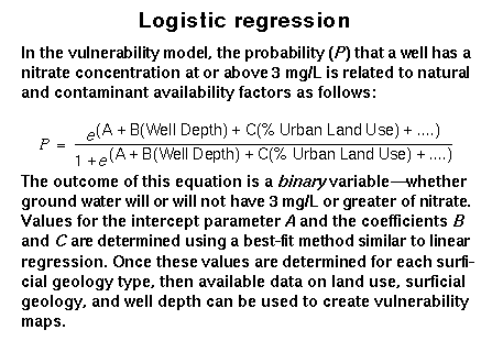