![[USGS]](visual_id-wrd.gif)
| Existing flood maps (around 1980) | ![[1982 map]](os410.gif) |
|
|
|
|
|
|
|
| Flood maps updated with our method | ![[Updated map]](n-o-n.gif) |
|
|
|
|
|
|
|
|
|
Existing flood maps need updating because, in the nearly 20 years since the original studies were completed, additional information has become available about peak flows and floodplain elevations that would significantly change the flood estimates these maps display. However, complete re-studies using traditional methods are expensive and time-consuming, so it is unlikely that the maps can be updated quickly enough to meet demand. We tested a method in Washington State for updating these maps quickly and efficiently, using modern, high-accuracy elevation data; geographic information systems (GIS) technology; and existing hydraulic models from detailed Flood Insurance Studies (FIS) conducted by the Federal Emergency Management Agency (FEMA).
How are flood maps produced?Most of the detailed FIS flood maps produced under FEMA's National Flood Insurance Program were prepared in the late 1970s and early 1980s. These maps were produced in three steps:
New flood maps and an efficient mapping method are needed
Existing maps for many rivers are based on out-of-date flood probability estimates
Typically, the original estimates were calculated on the basis of only a few decades of annual peak flow data; 10-20 years of additional data are now available. Twenty to thirty years of data is not enough to estimate with certainty the 100- or 500-year floods, so the additional data may significantly change the flood estimates. Therefore, the estimates should be recalculated periodically, which increases the need for a quick and affordable method for updating flood maps. In our pilot study (fig. 1), we revised the estimate of the 100-year flood flow for the Nisqually River near Olympia, Washington, from 33,000 to 40,000 cubic feet per second.
Additionally, existing flood maps are based on flow estimates that are calculated for only one or a few locations on a stream whereas the 100-year flood flow is unique to any location on a stream and increases in the downstream direction. It is possible to calculate the 100-year flood flow at numerous locations on streams (Tasker and Slade, 1994)—more realistically simulating flood conditions. If this is done, flood maps would need to be updated to reflect these varying flood flow estimates.
Most maps were made using elevation data of varying detail and accuracy
Many of the inundation maps produced in the 1970s used elevation data that are less accurate that the high-accuracy data sets that are or will be available in the next decade for most developed areas; accuracy estimates for the newer data are on the order of 1 ft.
|
Although many of the hydraulic models used in the older maps were based on relatively accurate elevation data for floodplain elevation cross sections, such as photogrammetrically derived 5-ft contour maps or on-the-ground surveys, inundation areas were frequently mapped using lower accuracy maps, such as the USGS 7.5-minute quad maps, which are accurate to only one-half of a contour interval (a contour interval is usually 20 ft). In fact, elevation data now or soon to be available are more accurate overall than many on-the-ground survey data because the newer data are much denser (fig. 2). |
![[Cross section and flood levels, Nisqually R.]](xsecs2.gif) Figure 2. (11,627 bytes) Cross section and flood levels for |
Complete re-studies cost too much
Largely because of the labor costs of hydraulic flow modeling and surveying cross-section elevations, complete re-studies are very expensive and funds for this work are limited. Tens of thousands of maps are outdated (Federal Emergency Management Agency, 1997), but at the current rate of revision, the average time between updates is too long to meet the needs of users.
Inundation maps for additional flood levels are needed
To make land-use and flood-mitigation plans, government agencies need maps for floods more likely than the 100-year flood. For example, maps for the 25-year flood are a better guide for identifying flood-prone properties.
By using existing studies, GIS, and high-accuracy digital elevation data, flood maps can be updated efficiently
Building on existing studies saves time and money
Our method doesn't change the way streamflow estimates for a given flood probability are calculated (step 1 of map production). But because our method builds on existing hydraulic models, one of the most time-consuming and expensive steps of re-studies--step 2, creating a new hydraulic model in order to update the flood profile--is eliminated.
In our pilot, we determined updated flood profiles by pro-rating from existing hydraulic models (fig. 3a)--specifically, by interpolating from the flood-elevation/streamflow relation (commonly known as the stage-discharge relation, or "rating curve," fig. 3b) generated at each cross section by earlier hydraulic calculations. This method greatly reduces the time required for this step because it builds on previous work. In most cases, the updated streamflow estimate for the 100-year flood will be less than the original 500-year flood (for which a previously computed flood profile is usually available)--allowing interpolation. However, the updated 500-year streamflow estimate will usually be greater than the original 500-year flow estimate (as was the case in our pilot area), so extrapolation is required. Extrapolation must be done with care, especially if the new flood may extend into a floodplain that was not inundated at the previous flood elevation. (Extrapolation will also be required when the 500-year flood profile is not available.) In our pilot, the results from extrapolation were in good agreement with re-running the hydraulic model with the new flow. (Interpolation and extrapolation are performed using an appropriate transformation, such as a base-10 logarithm.)
![[Schematic of flood profiles]](hydraulics.gif)
Figure 3. (11,350 bytes) Schematic showing how flood profiles are updated
We are currently investigating the possibility of revising the hydraulic model using the new elevation data to generate new cross sections. This method would make it possible to generate a larger number of more detailed cross-sections that have more accurate geographical locations than when using field survey data. However, below-water topography would still require field surveys or estimation. Revising the hydraulic model would be appropriate for streams with large changes in channel geometry, but would add significantly to the expense.
GIS-derived flood maps include depth information
GIS can create and manipulate digital elevation models representing the land surface and the flood surface. Elevation models of the flood surface are interpolated linearly between cross sections (fig. 3a), and , therefore, should be inspected carefully; for example, at oxbows, there may be linear extrapolations of water elevation information across the dry land where streams double back on themselves.
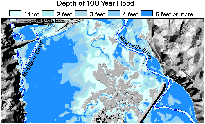
Determining the inundated area is a simple calculation: the flood surface elevation model is subtracted from the land surface elevation model at each location, resulting in negative values wherever the flood elevation is greater than the land elevation (fig. 4). A valuable by-product of this calculation is flood depth (fig. 5). This method does not identify floodways, but it is possible that a floodway surrogate could be estimated.
Figure 4. (a) Flood map from a 1982 study: 100-year-flood estimate of 33,000 cfs; (b) Updated 100-year flood map with new land elevation data (33,000 cfs); (c) Updated 100-year-flood map with new land and flood elevation data (40,000 cfs); (d) Aerial photograph of an approximate 100-year-flood in the pilot study area (Feb. 9, 1996). (The images below have been reduced for easy comparison. To view a full-size image, click on a small image below)
| (a) | (b) |
| (c) | (d) |
Figure 5. (71,592 bytes) Flood depth map produced by GIS
![[Flood depth map from GIS]](depths3-12.gif)
Areas of uncertainty can be mapped
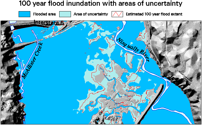
Another advantage of using GIS is the ability to map areas along the periphery of the inundated area where uncertainty in the flood or land elevations translates into uncertainty about the extent of inundation (fig. 6). It is a simple matter to adjust the flood elevation data by estimates of uncertainty or error, thereby delineating the areas where we have less confidence that flooding will occur. Both the digital land surface elevation data used to define channel geometry and inundation areas and the hydraulic models used to create the flood surface elevation data have associated error estimates. The area of uncertain flooding in figure 6 reflects only the error estimate associated with the elevation data. Figure 7 illustrates how error estimates can be applied.
Figure 6. (58,765 bytes) Flood map produced by GIS with areas of uncertain flooding
![[Map of uncertain flood extent]](uncertain3-10.gif)
Figure 7. Schematic of cross section and overhead view showing application of error estimates
![[Schematic of cross section and overhead view]](uncertain_exp3.gif)
Digital maps are more useful
Large-scale paper maps used to display inundation areas are difficult to store and distribute. They generally do not include roads, buildings, or other features, making it difficult to determine if they are in a flood area. These maps are problematic to digitize because they are not geographically referenced and usually lack sufficient detail to reference manually.
Flood maps produced with GIS allow users to overlay additional digital information such as roads, buildings, and critical facilities—allowing quick assessment of the potential impacts of a given flood level (fig. 8). Map storage and distribution is greatly simplified as well because maps can be stored and distributed electronically, and prepared at any scale.
![[GIS map with flood depth, roads, buildings]](structures2.gif)
Summary
Flood maps produced by detailed Flood Insurance Studies (around 1980) in many cases are in need of updates to both the flood level used for the maps and to the elevation data used to delineate inundation areas. We have presented a cost-effective approach to making these updates using the results of the earlier detailed hydraulic studies, new high-accuracy elevation data, and geographic information system mapping technology. The resultant maps are as accurate and more detailed than the existing maps; easily produce important ancillary information such as detailed flood depth maps; facilitate flood impact assessment and planning; and are comparatively simple to store and distribute.
References:
Federal Emergency Management Agency, 1997, Modernizing FEMA's flood hazard mapping program: Washington, D.C., Federal Emergency Management Agency, p. 6.
Tasker, Gary D., and Slade, Raymond M., Jr., 1994, An interactive regional regression approach to estimating flood quantiles, in Water Policy and Management--Solving the Problems--Proceedings of the 21st Annual Conference, Denver, Colo., 1994: New York, American Society of Civil Engineers, p. 782-785.
Suggested citation for this Web document:
Jones, Joseph L., and others, 1998, Updating flood maps efficiently--Building on existing hydraulic information and modern elevation data with a GIS: U.S. Geological Survey Open-File Report 98-200, from URL http://wa.water.usgs.gov/reports/floodgis/, accessed May 22, 1998, HTML format.
For more information, contact the primary author:
(253) 428-3600, ext. 2684
E-mail: jljones@usgs.gov
Water Resources of Washington State
Urban Geologic and Hydrologic Hazards
This document built and maintained by John M. Clemens (jclemens@usgs.gov)
This page is http://
wa.water.usgs.gov
/pubs/ofr/floodgis/index.html
Last modified: Mon Aug 24 11:02:48 1998
![[Location map of pilot area in the State of Washington]](location3.gif)
![[Flood map, 1982--100-year flood estimate]](old_big2.gif)
![[100-year flood map, new elevation data]](new33_big2.gif)
![[100 year flood map, new elevation and flood data]](new40_big2.gif)
![[Aerial photo, 100-year flood]](aerial_pic.gif)