


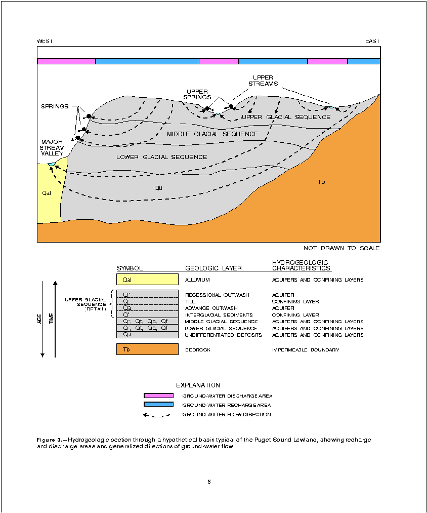
These four deposits (recessional outwash, till, advance outwash, and interglacial sediments) form the conceptual depositional sequence of layers that make up a single glacial sequence. Three such glacial sequences are included in the conceptual model of the hypothetical basin (fig. 3).
The youngest sediments in the Puget Sound Lowland are Holocene alluvium (Qal) that has been deposited along valleys by major streams emanating from the Cascade Range and the Olympic Mountains. These broad alluvial valleys have been filled by more than 300 ft of silt, sand, gravel and clay since the last glaciation. Tapped by many high-capacity municipal wells, the alluvium is an important aquifer within the Puget Sound Lowland.
The bedrock (Tb) consist largely of Tertiary claystone, siltstone, sandstone, and some beds of coal (Dion and others, 1994). Because of its low permeability, the bedrock is not an aquifer throughout most of the Puget Sound Lowland and, in the conceptual model of the basin, is considered an impermeable boundary to ground-water flow.
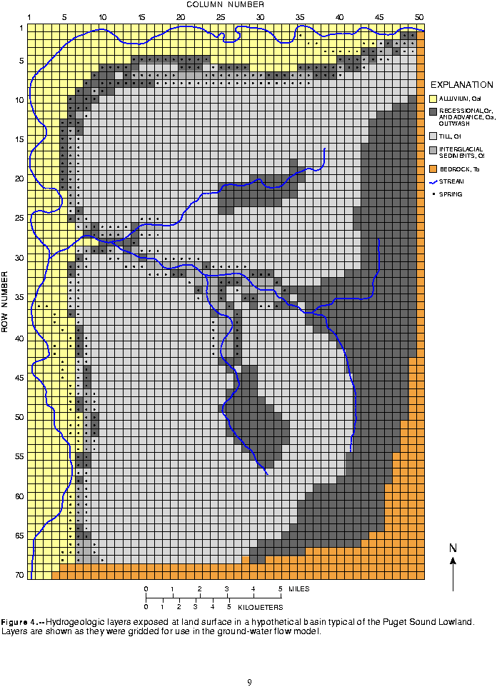
As they were deposited in the Puget Sound Lowland, these sediments (particularly the three glacial sequences) underwent erosion or reworking. Therefore, they are commonly irregular in thickness and composition, and, in some places, they are missing altogether. Geologic maps of the drift plains in the Puget Sound Lowland show large exposures of till (Qt) at the surface with lesser amounts of recessional outwash (Qr) and alluvium (Qal). Advance outwash and interglacial fine-grained sediments are exposed mostly along bluffs at the margin of the drift plain. These hydrogeologic layers and their distribution at the surface are represented in the surficial hydrogeology of the hypothetical basin (fig. 4).
The bedrock structure in the Puget Sound Lowland is roughly trough shaped in a north-south direction. The deepest part of the trough is typically beneath Puget Sound, where the unconsolidated deposits are more than 1,000 ft thick. In the hypothetical model, the maximum thickness of unconsolidated deposits was about 900 ft---where this total thickness exceeds the combined thickness of the three glacial sequences, an underlying layer of undifferentiated deposits (Qu) is part of the conceptual model (fig. 3). Northwest-trending bedrock ridges occur in parts of the Puget Sound Lowland, and this feature was incorporated in the hypothetical basin where bedrock ridges bound the basin on the west
and south (fig. 4).
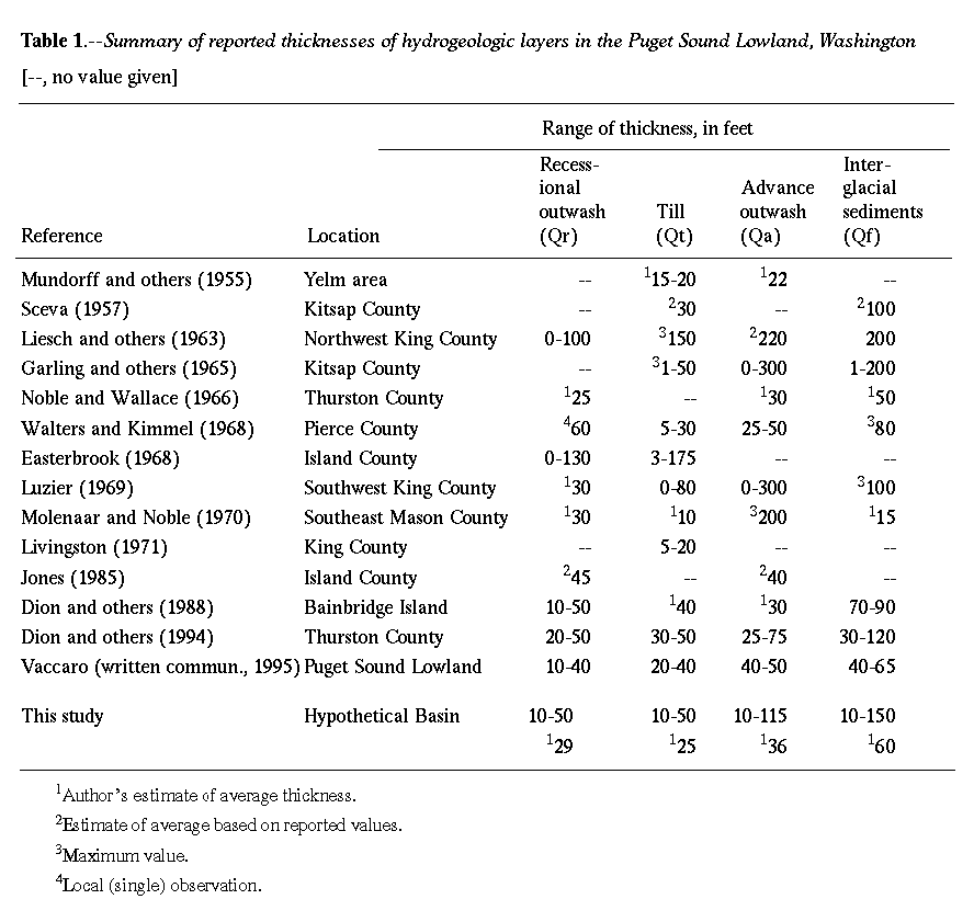
The thicknesses of aquifers and confining layers in the hypothetical basin were chosen by reviewing reports that describe analogous deposits in the Puget Sound Lowland and selecting reasonable values. Table 1 summarizes the findings of the review of literature and lists the values used for the hypothetical basin.
Geologic materials, such as the clays, silts, sands, and gravel that make up the aquifers and confining layers in the Puget Sound Lowland, transmit ground water at rates that are proportional to their hydraulic conductivity. Hydraulic conductivity is defined as the rate that ground water will move through a unit cross section of geologic material under a unit hydraulic gradient. Hydraulic conductivity has dimensions of length per unit time and is commonly expressed in units such as feet per day (ft/d) or centimeters per second. In most geologic materials, hydraulic conductivity varies with direction. In sedimentary deposits, the horizontal and vertical hydraulic conductivity can differ by orders of magnitude. Hydraulic conductivity is typically greatest in the horizontal direction because of the orientation of sediment particles and layers during deposition.
Vaccaro (J.J. Vaccaro, U.S. Geological Survey, written commun., 1993) examined estimates of hydraulic characteristics from 17 investigations for the various hydrogeologic layers in the Puget Sound Lowland. He found that the wide range of depositional settings in the region has resulted in an equally wide range in the hydraulic conductivity of the glacial and interglacial deposits.
Coarse-grained alluvium in the major stream valleys can have hydraulic conductivities ranging from 35 to 700 ft/d; however, values of 200 ft/d are more typical. Where finer-grained alluvium occurs, it is typically a fine-sand with silt and clay and has hydraulic conductivity values of about 1 to 15 ft/d (J.J. Vaccaro, U.S. Geological Survey, written commun., 1993). Both advance and recessional glacial outwash deposits have hydraulic conductivity values ranging from about 15 to 50 ft/d if they are predominately sand. Values of 100 ft/d are more typical for deposits containing significant fractions of gravel.
The hydraulic conductivity of till in the Puget Sound Lowland varies greatly. Permeameter measurements of hydraulic conductivity range from 0.0002 to 53 ft/d (J.J. Vaccaro, U.S. Geological Survey, written commun., 1993). Both this range and the median, 0.12 ft/d, are similar to values reported for till in southern New England, where the range and median were 0.00023 to 96 ft/d and 0.3 ft/d, respectively (Melvin and others, 1992). Little information is available to quantify the hydraulic conductivity of the fine-grained interglacial deposits; however, Vaccaro (J.J. Vaccaro, U.S. Geological Survey, written commun., 1993) suggests a range of 0.00001 to 1.0 ft/d, depending on the location and proximity to the source area of the sediments.
Recharge from infiltration of precipitation has been investigated in several studies in the Puget Sound Lowland. Woodward and others (1995) used a daily water-budget model to estimate ground-water recharge to eight basins in southwest King County. The model, referred to as the Deep Percolation Model (DPM), computes the amount of water that percolates below the root zone after runoff and evapotranspiration are deducted from precipitation (Bauer and Vaccaro, 1987). Dinicola (1990) also used a daily water-budget model to estimate recharge in 33 basins within the Puget Sound Lowland. Vaccaro (J.J. Vaccaro, U.S. Geological Survey, written commun., 1993) summarized the ground-water recharge estimates from these studies and the apparent controlling factors on recharge in the Puget Sound Lowland.
Most of the variability in recharge in the Puget Sound Lowland can be attributed to three factors: precipitation, surficial geology, and land use and cover (J.J. Vaccaro, U.S. Geological Survey, written commun., 1993). Dinicola (1990) found that where fine-grained glacial till or mudflow deposits were exposed at land surface, recharge rates were much less than where coarse-grained outwash deposits were exposed. After infiltrating through soils in areas underlain by till, most water generally moves laterally along the top of the till until it intercepts a stream channel or land surface. In contrast, where outwash deposits are exposed or immediately underlie the soil, water can freely percolate to the water table. The type of land use and cover controls the amount of precipitation that is lost to evapotranspiration and runoff. Deciduous and conifer forests, grasses, and other types of vegetation have varying water requirements that will affect the amount of water available for recharge. The most important land use or land cover in terms of its effect on recharge is impervious area. Impervious area is generally associated with urban development and includes streets, roofs, driveways and parking lots. Nearly all precipitation that falls on these areas either runs off or evaporates directly. The runoff may be routed either to sewers, ditches, or drywells, and subsequently none, some, or all of the runoff may eventually become recharge.
The mean annual precipitation in the 26 basins whose water budgets are summarized by Vaccaro (J.J. Vaccaro, U.S. Geological Survey, written commun., 1993) ranges from 25 to 61 in/yr. Estimated evapotranspiration and runoff ranged from 12 to 21 in/yr and 0 to 22 in/yr, respectively. Baseflow ranged from 0 to 22 in/yr. The range of recharge estimates, 5 to 29 in/yr, reflected the wide ranges of precipitation, evapotranspiration and runoff found in the Puget Sound Lowland.
Vaccaro used regression analysis to determine statistical relations between mean annual precipitation and recharge. The following equations were derived for areas where outwash and till are exposed at land surface:
Outwash areas:
 ,
,
Till areas:
 ,
,
where  is mean annual recharge in inches per year, and
  is mean annual precipitation in inches per year. Vaccaro (J.J. Vaccaro, U.S. Geological Survey, written commun., 1993) used these equations to estimate recharge within the Puget Sound Lowland. Estimated annual recharge in areas underlain by till and other fine-grained deposits averages 17.5 in. Estimated annual recharge in areas underlain by outwash and other coarse-grained deposits averages 35.9 in; the combined average annual recharge for the entire Puget Sound Lowland is 27 in. These same equations were used in this study to estimate recharge in the hypothetical basin.
Ground-water systems have frequently been categorized according to scale, based on the average length of the flow path between recharge and discharge areas (Toth, 1963; Freeze and Cherry, 1979). Woodward and others (1995) have applied the terms local, intermediate, and regional to flow systems in the Puget Sound Lowland and, for consistency, these terms will be used in this report. Local flow systems are characterized by short flow paths within shallow aquifers with small-scale topography usually controlling the location of recharge and discharge areas. At the other extreme, regional flow systems generally have long flow paths within deeper aquifers and are controlled by large-scale topographic features like the Cascade Range and Puget Sound. Intermediate flow systems fall between these extremes. Regional flow systems include the flow paths between the Cascade Range and the Puget Sound that extend mostly through the pre-Quaternary bedrock. Local flow systems generally exist within the upper few hundred feet of Quaternary sediments and recharge is mostly by infiltration of precipitation on the drift plains and discharge is by seepage or springflow onto small streams on the plains, or to larger streams in the adjacent major stream valleys. The major streams act as discharge boundaries to the local flow systems. Intermediate flow systems comprise the flow region above the bedrock and below the deepest part of the local flow system. This arbitrary boundary suggests that there is inter-basin flow above the bedrock under major stream valleys. However, the quantity of ground water underflow between basins defined by local flow systems would be small (W.E. Lum, U.S. Geological Survey, written commun., 1988).
The uppermost recessional outwash aquifer occurs in isolated pockets where it was deposited in topographic lows. It is generally considered to be a water-table aquifer where it is thick and saturated (Woodward and others, 1995). The uppermost till is thought to be saturated where it is overlain by saturated recessional outwash, and at least partially saturated where it is underlain by advance outwash under confined conditions (Woodward and others, 1995). Aquifers beneath the uppermost till are generally confined except near their edges where they have been truncated at bluffs and in canyons by post-Pleistocene erosion. Seepage faces and springs on the bluffs and canyon walls partially dewater the aquifer for some distance from the edge of the aquifer (fig. 3); Woodward and others (1995) suggest that the dewatered zones are typically 0.3 mi wide.
In the major stream valleys, water levels in deeper wells are higher than those in shallow wells, indicating upward flow of ground water and supporting the concept that the major stream valleys are the principal discharge areas for the basin. In wells less than 50 ft deep, water levels are generally a few feet below land surface, but in wells more than 100 ft deep, water levels are above land surface.
Baseflow to streams has been estimated by hydrograph separation for several small basins in the Puget Sound Lowland. Woodward and others (1995) estimated baseflow ranging from 4 to 21 in/yr for eight basins; the mean baseflow was 11 in/yr (0.81 ft3/s/mi2). Baseflow in 26 basins in which recharge estimates were made by Vaccaro (J.J. Vaccaro, U.S. Geological Survey, written commun., 1993) ranged from 0 to 22 in/yr with a mean of about 14 in/yr (1.03 ft3/s/mi2). Both studies found that baseflow averaged about 36 percent of average annual precipitation. Baseflow for specific stream reaches has been estimated by making gain-loss measurements, but few of these results have been published. Unpublished gain-loss data for the Soos Creek Basin in southwest King County indicate that individual reaches of Soos Creek gain from 0.3 to 3 ft3/s/mi (D. G. Woodward, U.S. Geological Survey, written commun., 1992). Rates of discharge to major streams are not available.
Spring and seep discharge is difficult to quantify over an entire basin. Individual springs with discharge large enough to measure often do not make up the majority of spring discharge in a basin. More typically, most discharge is to small springs and seeps that cannot be directly measured and are distributed over large areas. Some investigators have attempted to estimate discharge for springs that discharge from the bluffs above major stream valleys in the Puget Sound Lowland. Woodward and others (1995) reported estimates ranging from 0.01 to 0.27 ft3/s/mi, based on spring inventories done by Luzier (1969). These estimates do not include discharge to seepage faces along the bluffs. Woodward and others (1995) suggested that this diffuse discharge could be estimated using potential evapotranspiration (PET) as an index. Phreatophytes are plants whose roots draw water from below the water table. If 25 percent of a 350 ft high bluff is wet or covered by phreatophytes, discharge can occur over an area of 462,000 ft2/mi. If this area is assumed to transmit water to the atmosphere at the PET rate of 27 in/yr, then the total annual discharge would be 1.04 x 106 ft3/yr/mi, or 0.03 ft3/s/mi. This would be a minimum rate of discharge and is probably much less than the actual rate.
In some areas, a large percentage of spring discharge reaches the stream channel. The contribution of spring discharge to the baseflow of the stream is often indiscernible from direct ground-water discharge to the streambed. Several large (10 to 20 ft3/s) springs and many smaller (1 ft3/s) springs contribute to the Nisqually River in Thurston County, and it is estimated that the spring discharge makes up most of the baseflow of the river in some areas (W.E. Lum, U.S. Geological Survey, personal commun., 1992).
Ground water is lost to the atmosphere by evaporation from bare soils and by transpiration from the leaves of phreatophytes. The rate of steady evaporation from bare soil diminishes rapidly with increasing depth to the water table and is negligible for most soils if the water table is more than a few feet below land surface. Transpiration rates are dependent on the type and density of phreatophytes, climatic conditions, quality of water, and depth to water. Evapotranspiration of ground water is an important part of total ground-water discharge in the major stream valleys where the water table is within a few feet of land surface (J.J. Vaccaro, U.S. Geological Survey, written commun., 1993). On the upper drift plains the water table generally lies deeper than the roots of phreatophytes can reach except near small streams, where the water table is shallow. In these areas near streams, ground water probably discharges by evapotranspiration at nearly the PET rate.
As many as 30,000 wells in the Puget Sound Lowland withdraw ground water for public supply, domestic, irrigation, commercial, industrial, and institutional purposes (J.J. Vaccaro, U.S. Geological Survey, written commun., 1993). According to Vaccaro, ground water supplied 43 percent of all water used in the Puget Sound Lowland in 1990. Typically, ground water makes up an even larger percentage of domestic supplies; for example, in southwestern King County in 1986, the household water needs of 70 percent of the population were supplied by ground water (Woodward and others, 1995). Dion and others (1994) reported that ground water supplied all household water in northern Thurston County in 1988. In northern Thurston County and many other localities in the Puget Sound Lowland, springs are used to supply water for domestic and other uses. Most of the ground-water withdrawals are from the alluvial deposits underlying the major stream valleys and from confined outwash aquifers within the upper 100 to 200 ft on the drift plains. The unconfined recessional outwash deposits on the drift plains are used where they are locally saturated, but they are not an important source in the region.
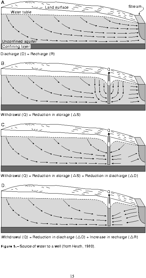
Prior to development of a ground-water system by wells, the system is in a state of equilibrium (steady state) where the natural discharge ( ) is exactly equal to the natural recharge (
 ) when considered over a sufficiently long time period (fig. 5a). Over short time periods, recharge and discharge may not be equal due to normal seasonal variations in climate. However, if average annual climate conditions prevail for successive years, recharge and discharge will be in equilibrium over this period. When recharge and discharge are not equal, ground water is either added to or removed from storage. When recharge exceeds discharge, ground-water storage is increased; conversely when discharge exceeds recharge, ground-water storage is reduced.
When a well begins to withdraw water from a ground-water system, water is removed from storage as the water level drops, forming a cone of depression (fig. 5b). At this stage, the withdrawal ( ) is balanced entirely by a reduction in storage (
 ):
):
 .
.
As pumping continues, the cone of depression will expand until it reaches an area where ground water naturally discharges, as to a stream or spring. The cone of depression will reduce the hydraulic gradient toward the discharge area, decreasing the natural discharge to the stream or spring by an amount,  (fig. 5c). The withdrawal will then be balanced by the change in storage,
  , and the reduction, or capture, of natural discharge,
  :
:
 .
.
The term "capture" is used in this report to describe the change in location of discharge that occurs when a new stress is imposed on a ground-water system. This term should not be confused with the term "capture area," which is commonly used to describe the contributing area to a well in well-head protection analyses.
The cone of depression will continue to expand as water is removed from storage until it has expanded into a large enough area to capture sufficient natural discharge to completely balance the withdrawal. Once this new balance is achieved, the ground-water system is in a new state of equilibrium
( ) and reduced natural discharge (
 ) plus withdrawals (
 ) equal natural recharge (
 ):
):
 .
.
It is clear from equation 5 that captured natural discharge ( ) must be equal to the withdrawal
( ) at equilibrium.
If the cone of depression expands into a recharge area rather than a discharge area, the hydraulic gradient between the well and the recharge area will be increased. If more water was available than the aquifer could accept as recharge under natural conditions, the increased gradient may allow additional recharge ( ) to occur. If and when the increase in recharge plus any decrease in discharge (
 ) equals the withdrawal, a new equilibrium will be established:
 .
.
In some cases, where pumped wells are located near a stream or the cone of depression expands far enough, the hydraulic gradient can be reversed such that ground-water discharge to the stream stops entirely and water will be induced to move from the stream into the aquifer as additional
recharge (fig. 5d).