


The baseline model was then used to test the effects of one or more discharging wells on ground-water discharge to streams and springs. Several series of simulations were made; each series was designed to show the effect of changes in one variable on ground-water discharge. Variables considered included well depth, distance between well and stream, well discharge rate, and others.
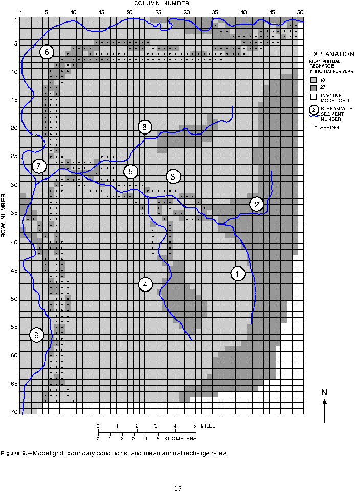
The MODFLOW program requires that the ground-water system be subdivided, vertically and horizontally, into a finite difference grid of rectangular blocks or cells. The hydraulic properties of the flow system are assumed to be homogeneous within each cell. The saturated flow system of the hypothetical basin was subdivided vertically into 13 layers and horizontally into a 50 column by 70 row grid of 3,500 square cells, each having dimensions of 1,500 ft per side (fig. 6).
Each of the unconsolidated hydrogeologic layers of the conceptual model of the hypothetical basin is represented by an individual layer in the model; bedrock is not explicitly included as a layer in the model, but is represented numerically as a boundary to the system as discussed below. The three glacial sequences, each consisting of four hydrogeologic layers, are represented by the upper 12 model layers, where these layers are present beneath the drift plain. The undifferentiated Qu, are included in the model as the bottom layer (13) beneath the drift plain. The alluvial sediments, Qa, which occur only beneath the major stream valley, were represented in layers 9 through 13 in that part of the model.
Transmissivity, which is the product of the horizontal hydraulic conductivity of the aquifer and its saturated thickness, was specified for each cell. Transmissivity was not changed in the simulations because simulated pumping did not significantly reduce the saturated thickness of aquifers.
The northern and western boundaries of the numerical model coincide with the major stream valleys bounding the drift plain. The streams within these valleys are conceptualized as the discharge areas for local- and intermediate-scale ground-water flow systems in the lowlands; all ground water that enters the system as recharge within the hypothetical basin is assumed to leave the system as discharge within the boundaries of the model. The northern and western boundaries of the model were also specified as no-flow boundaries to reflect the assumption that there is no subsurface ground-water flow out of the basin.
Head-dependent flux boundaries were used to represent ground-water discharge from within the basin by seepage to streams and springs (fig. 6). The underlying equations of these boundary conditions are described by McDonald and Harbaugh (1988).
Based on the horizontal hydraulic conductivity value of 0.25 and the anisotropy ratio of 100, the effective vertical hydraulic conductivity of the till was 0.0025 ft/d. This value is within the range of 0.001 to 0.01 ft/d reported by Vaccaro (J.J. Vaccaro, U.S. Geological Survey, written commun., 1993). The vertical hydraulic conductivity of the interglacial deposits was about 0.005 ft/d, or twice that of the till layers.
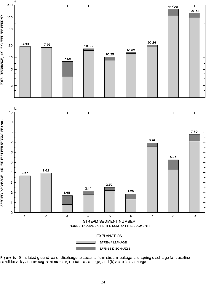
Stream reaches are defined as the lengths of stream contained within one model cell; stream segments are groups of contiguous reaches that have no tributaries. Streams in the basin are identified by segment numbers, with nine stream segments in the basin: segments 1 through 7 on the upper drift plain and segments 8 and 9 in the lower stream valleys (fig. 6).
Head-dependent boundary conductances are analogous to the vertical conductance between model layers. However, boundary conductances are adjusted external to the model to account for the area of a cell that is covered by the boundary, whereas vertical conductances are adjusted internally. The generalized boundary-conductance equation is
 ,
,
where  is the boundary conductance,
  is the vertical hydraulic conductivity of the sediments between the stream and the center of the model cell containing the stream,
  is the area of the stream within the model cell, and
  is the thickness of sediments between the stream and the center of the model cell containing the stream.
Values of boundary conductance for the streams were estimated by assuming that the vertical hydraulic conductivity ( ) of sediments between the stream and the cell is equal to 2 percent of the horizontal hydraulic conductivity of the cell. The average stream area in a cell was estimated by measuring the length of each reach and assuming a width of 10 ft. Although no discrete, low-permeability streambed may be present, a thickness (
 ) must be assumed at each model cell to describe the equivalent thickness of the materials that restrict the flow of water between the stream and the ground-water system. This thickness was specified as 2 ft throughout the model. The conductance values resulting from these assumptions are essentially lumped parameters that represent a proportionality constant that determines the flux between the ground-water system and the stream for a given difference between stream stage and ground-water level. The weighted-mean streambed conductance values used in the model ranged from 3,300 ft2/d for segment 5 to 14,600 ft2/d for segment 2; the overall weighted mean conductance was 7,800 ft2/d.
 , of the seepage face at each spring was assumed to span the entire width of the cell (1,500 ft) and the height of the seepage face was assumed to be half of the thickness of the cell. The hydraulic conductivity,
  , of the spring was estimated to be the same as that of the hydrogeologic layer of the cell. The length of the flowpath,
  , was the distance from the cell center to the seepage face (750 ft). Using these assumptions, mean spring conductances for spring cells ranged from 1,300 ft2/d for layer 11 to 2,900 ft2/d for layer 3, with an overall mean of 2,400 ft2/d. The discharge altitude for each spring cell was specified as the altitude of the bottom of the aquifer at the point where it is exposed on the bluff or canyon. The 164 spring cells in layer 3 discharged from a mean altitude of 340 ft, and the 25 spring cells in layer 11 discharged from a mean altitude of 66 ft.
The baseline model simulates ground-water flow in the hypothetical basin prior to any withdrawal of ground water by wells. The system was assumed to be at equilibrium, or steady state, with discharge balanced by recharge. The expected hydrologic conditions used to calibrate the baseline model are based on data from studies of several areas in the Puget Sound Lowland. Although these data may not reflect steady-state conditions in all cases, the generalized expected conditions are probably typical of the conditions that would be found in an undeveloped basin.
In the following sections, ground-water levels, hydraulic head gradients, and ground-water discharge rates simulated with the baseline model are compared with conditions that would be expected in the typical Puget Sound Lowland basin.
Throughout the drift plain, the simulated vertical component of ground-water flow is downward, except in shallow aquifers near streams where there is upward flow toward the stream. Heads decrease with depth beneath the drift plain, which is a recharge area. Head differences between adjacent aquifers are greatest in the shallow aquifers underlying the plain near the bluff and decrease with depth and to the east and south. Differences in simulated heads are as much as 120 ft between shallow aquifers near the bluff and as little as 20 ft between deep aquifers near the eastern and southern edges of the basin. These simulated differences compare closely with expected differences based on data for southwest King County from Woodward and others (1995), who found differences ranging from about 40 to 150 ft between water levels in the uppermost confined outwash aquifers. Simulated heads increase with depth beneath the major stream valley, which is a discharge area. The maximum simulated vertical head differences between the shallow and deep aquifers beneath the major stream valley were 10 to 20 ft.
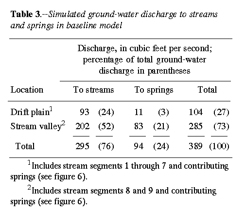
Annual baseflow averages about 36 percent of precipitation in Puget Sound Lowland basins (J.J. Vaccaro, U.S. Geological Survey, written commun., 1993). The assumed annual precipitation of 44 in/yr in the hypothetical basin would result in baseflow of about 16 in/yr. Over the 262 mi2 basin this would result in 308 ft3/s of baseflow. The simulated total seepage to streams in the hypothetical basin is only 295 ft3/s (table 3); however, this figure does not include any spring discharge that might flow into the stream and contribute to baseflow. Of the 94 ft3/s of spring discharge, it is likely that at least 13 ft3/s, which is the difference between the simulated and expected baseflows, contributes to streamflow in the basin.
Another assessment of the simulated discharge to streams was made by comparing simulated discharge to streams on the drift plain with estimated baseflow in a small basin in southwest King County. Big Soos Creek (fig. 1) drains an area of 66.7 mi2 and has a mean monthly flow of about 35 ft3/s for October (1967-92), a time when flow in streams in the Puget Sound Lowland are supplied almost entirely by baseflow. This discharge represents the best available estimate of minimum annual baseflow to Big Soos Creek, since baseflow is typically greater during winter and spring months when the water table is higher. Based on this estimate, the minimum baseflow per square mile is 0.52 ft3/s. The drift plain of the hypothetical basin covers about 188 mi2 and therefore the expected minimum baseflow, based on the Big Soos Creek data, is about 100 ft3/s. Simulated discharge to streams on the drift plain was 93 ft3/s by seepage and 11 ft3/s from spring discharge, for a total of 104 ft3/s.
According to Vaccaro (J.J. Vaccaro, U.S. Geological Survey, written commun., 1993), estimated annual baseflow in 12 Puget Sound Lowland basins averages about 0.93 ft3/s/mi2, or nearly twice the minimum baseflow of 0.52 ft3/s/mi2 estimated above. Using the higher value, the expected annual baseflow from the 188 mi2 drift plain in the hypothetical basin would be 175 ft3/s. This value may be a more realistic estimate for comparison with the simulated baseflow, since the model simulates average annual baseflow. On this basis, the simulated baseflow of 104 ft3/s may be somewhat lower than what would be expected from an area this size. There are several sources of uncertainty in the estimate of annual baseflow. Considering only the uncertainty in determining the area contributing to baseflow, the uncertainty in the estimate of annual baseflow is probably  percent or more. Because simulated baseflow from the drift plain (104 ft3/s) falls within the range of estimated baseflow (100 to 175 ft3/s), the distribution of ground-water discharge in the model is a reasonable representation of a typical basin.
The rate of ground-water discharge per mile of stream, or specific discharge, was computed for each stream segment (fig. 9b). Including streams and springs, stream segments 1 through 6 had simulated specific discharges ranging from 1.68 to 3.92 ft3/s/mi, while segments 7 through 9 had discharges ranging from 5.25 to 7.79 ft3/s/mi (fig. 9b). The large difference is due to the positions of segments 7 through 9 in the lower part of the flow system where they receive discharge from a broader recharge area than do the streams on the drift plain. If spring discharge is not included, specific discharge to streams on the drift plain ranges from 0.8 to 3.9 ft3/s/mi (segments 1 through 6 only); this range is similar to the range of 0.3 to 3 ft3/s/mi determined for reaches of Big Soos Creek in southwest King County (Woodward and others, 1995).
The specific discharge of simulated springs was computed by dividing the total discharge of springs contributing to each stream segment by the length of spring discharge area adjacent to that stream segment. Specific discharges ranged from about 0.3 to 1 ft3/s/mi. The values at the lower end of this range are comparable to values at the upper end of the range of 0.01 to 0.27 ft3/s/mi reported by Woodward and others (1995) for southwest King County. As many as four outwash aquifers are exposed on the bluffs above the major stream valley, and of the 453 spring cells in the model, 78 percent are located on these bluffs. Consequently, some of the highest specific discharges for springs (0.7 and
1.0 ft3/s/mi) are on segments 8 and 9 in the major stream valley below the bluffs. Discharge per spring, however, is not significantly higher; the springs on the bluffs comprise 78 percent of all springs in the model and account for 88 percent of the total spring discharge, whereas springs on the drift plain comprise 22 percent of all springs and discharge 12 percent of total spring discharge (table 3).