
Search our site:
Project ContactsMark Mastin,
Hydrologist,
934 Broadway,
Suite 300
Tacoma, WA 98402
(mcmastin@usgs.gov)
(253) 552-1609
FEMA High Water Marks - Western Washington Flood, January 2009
Maps
#!/usr/bin/perl -- -*-perl-*- # This script displays the navigation bar for all project pages. #---------------------------------------------------------------------------------------------------------------------- # Print html header #---------------------------------------------------------------------------------------------------------------------- print "Content-type: text/html\n\n"; #---------------------------------------------------------------------------------------------------------------------- # Retrieve query string and specify variables for links. #---------------------------------------------------------------------------------------------------------------------- $publications_link = "Publications and Products | "; $links_link = "Related Links | "; $news_link = "News Releases | "; $data_link = "Data | "; $maps_link = "Maps | "; $science_link = "Scientific Topics | "; $bibliography_link = "Bibliography | "; $status_link = "Status | "; $database_link = "Database | "; $acknowledge_link = "Acknowledgments | "; $photo_link = "Photo Gallery | "; $asses_link = "Assessment Document | "; $gis_link = "GIS and Aerial Photography Sources | "; $contact_link = "Contact Us | "; $flood_link = "Flood Hazards | "; $path = $ENV{'QUERY_STRING'}; $path =~ s/%([0-9|A-F]{2})/pack("C",hex($1))/eg; $path =~ s/[;<>\*\|'&\$!#\(\)\[\]\{\}:"\\\/]//g; $path = "../projects/".$path."/includes/".$path.".config"; #---------------------------------------------------------------------------------------------------------------------- # Open the configuration file for the specific project. #---------------------------------------------------------------------------------------------------------------------- require $path; #---------------------------------------------------------------------------------------------------------------------- # Print table head #---------------------------------------------------------------------------------------------------------------------- print qq~| Project Home | ~; #---------------------------------------------------------------------------------------------------------------------- # Determine which links to display for specific project, based on configuration file. #---------------------------------------------------------------------------------------------------------------------- while ($status > 0) { print "$status_link"; $status = 0; } while ($publications > 0) { print "$publications_link"; $publications = 0; } while ($links > 0) { print "$links_link"; $links = 0; } while ($news > 0) { print "$news_link"; $news = 0 } while ($data > 0) { print "$data_link"; $data =0; } while ($maps > 0) { print "$maps_link"; $maps = 0; } while ($science > 0) { print "$science_link"; $science = 0; } while ($bibliography > 0) { print "$bibliography_link"; $bibliography = 0; } while ($database > 0) { print "$database_link"; $database = 0; } while ($acknowledge > 0) { print "$acknowledge_link"; $acknowledge = 0; } while ($photo > 0) { print "$photo_link"; $photo = 0; } while ($asses > 0) { print "$asses_link"; $asses = 0; } while ($gis > 0) { print "$gis_link"; $gis = 0; } while ($contact > 0) { print "$contact_link"; $contact = 0; } while ($flood > 0) { print "$flood_link"; $flood = 0; } #---------------------------------------------------------------------------------------------------------------------- # Print table footer #---------------------------------------------------------------------------------------------------------------------- print qq~ Project Summaries | Partnerships | | |
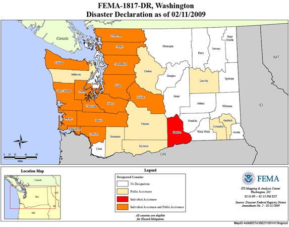
Figure 1. Map showing FEMA Disaster Declaration Counties.
Click on any of the reach maps (figure 2-8) to link to the data page that contains the high-water mark information.
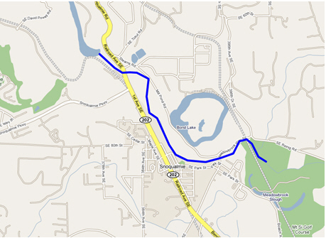
Figure 2. Snoqualmie River near Snoqualmie, Washington. the extent of flooding was surveyed in the lighlighted stream reach.
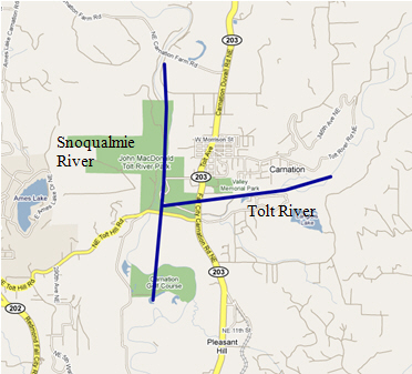
Figure 3. Snoqualmie and Tolt Rivers near Carnation, Washington. The extent of flooding was surveyed in the highlighted stream reaches.
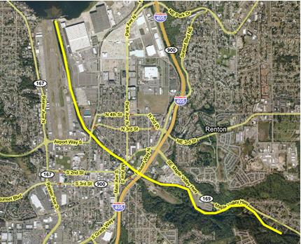
Figure 4. Cedar River near Renton, Washington. The extent of flooding was surveyed in the highlighted stream reach.
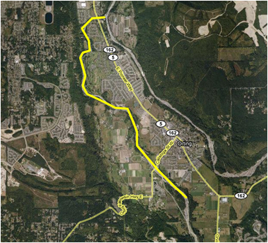
Figure 5. Puyallup River near Orting, Washington. The extent of flooding was surveyed in the highlighted stream reach.
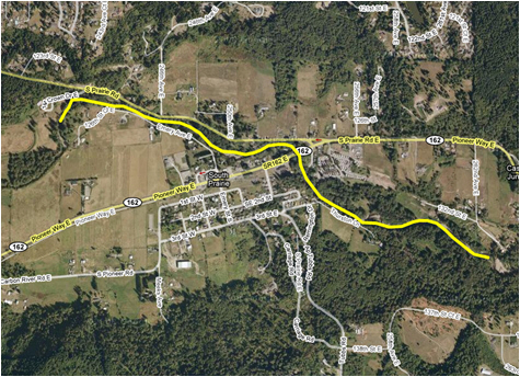
Figure 6. South Prairie Creek near South Prairie, Washington. The extent of flooding was surveyed in the highlighted stream reach.
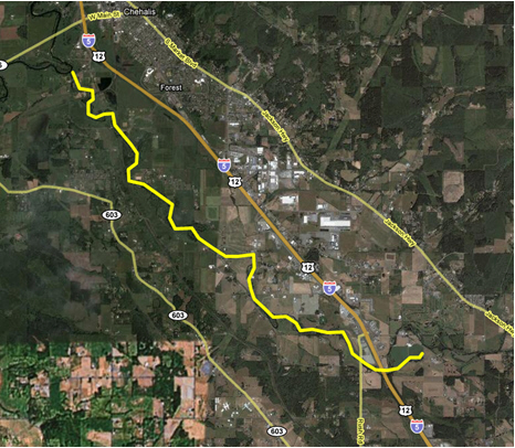
Figure 7. Newaukum River near Chehalis, Washington. The extent of flooding was surveyed in the highlighted stream reaches.
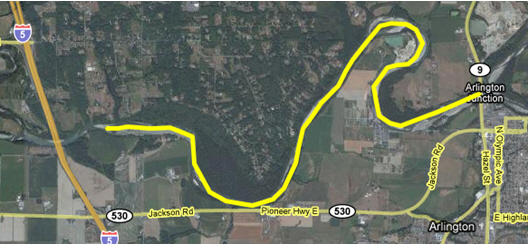
Figure 8. Stillaguamish River near Arlington, Washington. The extent of flooding was surveyed in the highlighted stream reach.